Uttarakhand River System
Uttarakhand is one of India’s most water-resource-rich Himalayan states. The rivers of Uttarakhand not only shape its geography but also define its culture, economy, pilgrimage routes, and historical development. Most rivers here flow south or south-eastward, finally becoming part of the Ganga River System at the national level.
However, within the state, Uttarakhand possesses distinct river systems and sub-systems, mainly:
- Ganga System
- Yamuna System
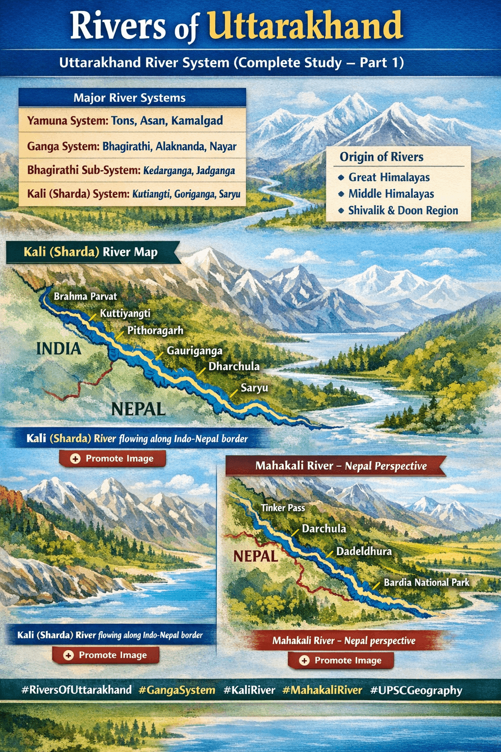
- Kali (Sharda / Mahakali) System
This article presents a systematic and exam-oriented explanation of Uttarakhand’s river systems along with their origin, tributaries, basins, and regional classification.
Major River Systems of Uttarakhand
| River System / Sub-System | Major Tributaries |
|---|---|
| Yamuna System | Rishiganga, Krishnagad, Bhadrigad, Kamalgad, Tons, Giri, Asan |
| Ganga System | Bhagirathi, Alaknanda, Nayar (Nadganga), Song, Chandrabhaga, Ratmau, Solani |
| Bhagirathi Sub-System | Rudraganga, Milan Ganga, Kedarganga, Jadganga, Siyaganga, Bhilgana |
| Alaknanda Sub-System | Saraswati, Dhauliganga (W), Nandakini, Pindar, Mandakini |
| Kali (Sharda) System | Kutiangti, Goriganga, Saryu, Lohawati, Ladhia |
Origin of Rivers Based on Himalayan Regions
Great Himalayas
Bhagirathi, Alaknanda, Nandakini, Pindar, Mandakini, Bhilgana, Kali, Eastern Ramganga, Yamuna, Tons
Middle (Central) Himalayas
Western Ramganga, Nayar, Khoh, Saryu, Gomti, Kosi, Gola, Panar, Ladhia
Shivalik & Doon Region
Begul, Nihal, Song, Rispana, Nandhaur, Bhakra, Dhela, Malin
Yamuna River System
The Yamuna River originates from the Yamunotri Glacier, located on the western slope of Bandarpoonch Peak in Uttarkashi district. Flowing through Uttarkashi and Dehradun, the river finally exits Uttarakhand.
Major Tributaries of Yamuna
Rishiganga, Hanumanganga, Krishnagad, Banadgad, Kamalgad, Tons, Asan
Tons River – The Largest Tributary
- Carries 2.5 times more water than Yamuna
- Formed by Supin + Rupin Rivers
- Known as Tamsa for some distance
- Joins Yamuna between Kalsi and Dakpathar
- Length along Uttarakhand–Himachal border: 148 km
📏 Length of Yamuna
- Yamunotri to Dhalipur (Uttarakhand): 136 km
- Yamunotri to Prayagraj: 1384 km
Major River Basin Areas (sq. km)
| River Basin | Area |
|---|---|
| Kali (Sharda) | 11,467 |
| Alaknanda | 10,951 |
| Bhagirathi | 7,880 |
| Kosi | 6,753 |
| Ramganga | 6,205 |
| Yamuna | 2,404 |
| Tons | 2,390 |
| Nayar | 1,921 |
Ganga River System in Uttarakhand
The river is known as Bhagirathi from Gangotri to Devprayag. After the confluence of Bhagirathi and Alaknanda at Devprayag, it becomes the Ganga.
Important Confluences
- Nayar (Nadganga) joins near Phoolchatti
- Chandrabhaga joins near Rishikesh
- Song River joins near Raiwala
- Ratmau & Solani join in Haridwar district
📏 Length of Ganga in Uttarakhand: 96 km (Devprayag to Haridwar border)
Bhagirathi Sub-System
- Origin: Gomukh (Gangotri Glacier)
- Total length: 205 km
- Tributaries: Rudraganga, Jadganga, Kedarganga, Asiganga, Siyaganga, Bhilgana
The Bhilgana River meets Bhagirathi at Ganesh Prayag (Old Tehri).
Alaknanda Sub-System (Vishnu Ganga)
- Origin: Satopanth Glacier
- Length: 195 km
- Major Tributaries:
- Saraswati (Keshav Prayag)
- Dhauliganga (Vishnu Prayag)
- Nandakini (Nand Prayag)
- Pindar (Karna Prayag)
- Mandakini (Rudra Prayag)
At Devprayag, Alaknanda (daughter-in-law) meets Bhagirathi (mother-in-law) to form the Ganga.
Nayar Sub-System
The Nayar River is formed by:
- Eastern Nayar (origin: Dudhatoli – Susi Gad)
- Western Nayar (origin: Dudhatoli – Seyoli Gad & Dhaijuli Gad)
They meet near Satpuli, later joining the Ganga near Phoolchatti.
Western Ramganga & Kumaon Rivers
- Western Ramganga originates from Dudhatoli Range
- Kosi River originates near Kausani
- Other east-flowing rivers: Dabka, Bakra, Gaula (Gargi), Deoha, Nandhaur
Other Post
History of Uttarakhand (Modern Period)