Uttarakhand Physical Structure – Part 1

Geographical Extent, Boundaries and Himalayan State Concept
Today, in Uttarakhand Physical Structure – Part 1, we study the geographical extent of Uttarakhand. This article explains where Uttarakhand is located, how large it is, and why it is called a Himalayan state. The remaining points of Uttarakhand’s physical structure will be discussed in the next article.
Geographical Extent of Uttarakhand
Uttarakhand is situated between the Greater Himalayas and the Gangetic Plain. On the globe, the state extends between 28°43′ to 31°27′ North latitude and 77°34′ to 81°02′ East longitude.
Thus, its latitudinal extent is 2°44′, and its longitudinal extent is 3°28′.
The shape of Uttarakhand is almost rectangular. The length of the state from east to west is about 358 km, while the north to south width is about 320 km.
Area and District Size
According to the State Statistical Diary 2008–09, the total area of Uttarakhand is 53,483 square kilometres, which is only 1.69% of India’s total area.
In terms of area, Uttarakhand is the 18th largest state of India.
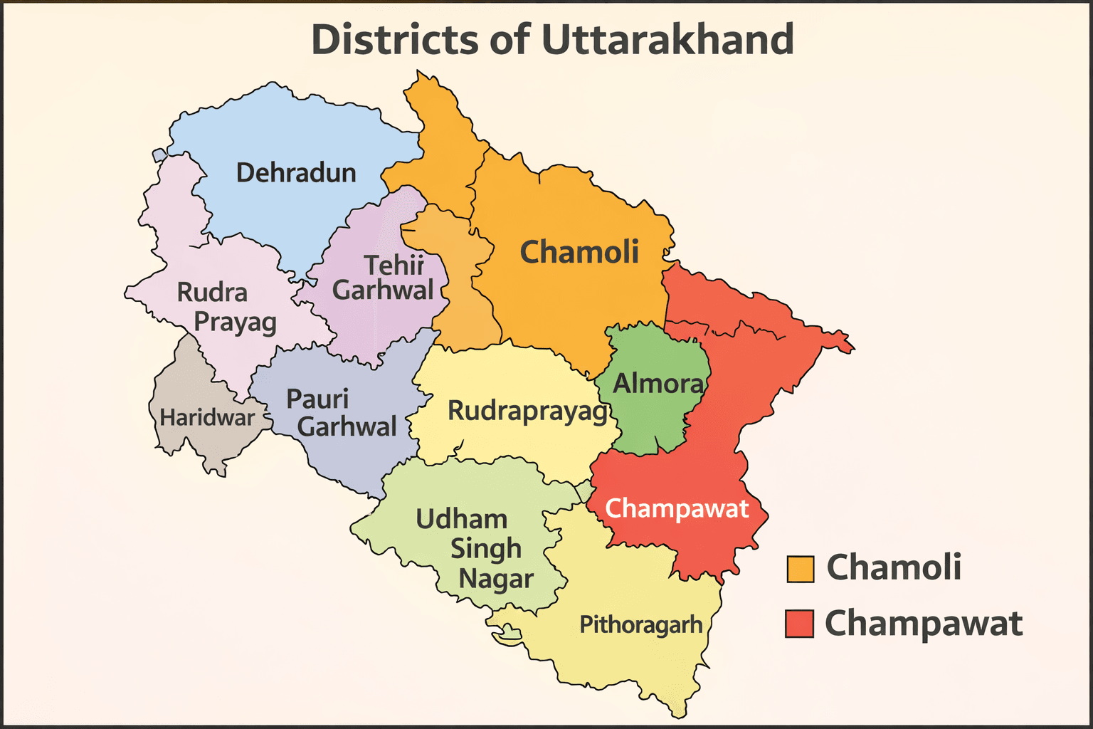
- Largest district: Chamoli (8,030 sq km)
- Smallest district: Champawat (1,766 sq km)
About 86.07% (46,035 sq km) of the state is mountainous, while 13.93% (7,448 sq km) is plain (Terai region).
Natural Boundaries

Uttarakhand is surrounded by strong natural boundaries.
The Great Himalayas lie in the north, the Tons River forms the western boundary, and the Shivalik ranges lie in the south-west. The Terai region is found in the south and south-east, while the Kali River forms the eastern boundary.
Political Boundaries and Strategic Importance
Uttarakhand shares its borders with Nepal in the east, China (Tibet) in the north, Himachal Pradesh in the north-west, and Uttar Pradesh in the south.
The northern and eastern borders are international, which makes the state strategically very sensitive.
Passes and Entry Routes
Many important mountain passes are located in the Trans-Himalayan region and the Greater Himalayan (Himadri) region. Before 1962, groups such as Shauka, Johari and Jad used these passes to trade with the Huniyas of Tibet.
From the plains, entry into Uttarakhand is possible through the Shivalik, Bhabar and Terai regions. Major entry gates include Mohand Pass, Timli, Haridwar, Kotdwar, Haldwani, Kathgodam and Tanakpur.
District-wise Location
- Northernmost district: Uttarkashi
- Southernmost district: Udham Singh Nagar
- Easternmost district: Pithoragarh
- Westernmost district: Dehradun
Pauri district touches seven districts, which is the highest in the state.
Only Tehri, Rudraprayag, Bageshwar and Almora are completely internal districts.
Pithoragarh has the longest international boundary with Nepal and also the largest border with China.
Himalayan State Concept
During national development planning, it was realized that hilly regions were developing more slowly than plains. Development in mountainous areas is difficult because their geographical, economic, cultural and resource conditions are different.
Therefore, Himalayan regions were treated as a separate development area, and the Himalayan State Concept emerged.
At independence, Assam was the only Himalayan state. Later, Jammu and Kashmir, Nagaland, and finally Uttarakhand were added. Uttarakhand became the 11th Himalayan state of India.
📌 Note
The remaining topics such as climate, altitude-based climate division, geographical divisions, natural calamities and disaster management will be explained in the next article (Part 2).
Releted Post: